


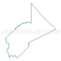
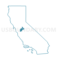
Voting District 51100, Stanislaus County, California
About
Outline

Summary
| Unique Area Identifier | 545141 |
| Name | Voting District 51100 |
| County | Stanislaus County |
| State | California |
| Area (square miles) | 0.77 |
| Land Area (square miles) | 0.77 |
| Water Area (square miles) | 0.00 |
| % of Land Area | 100.00 |
| % of Water Area | 0.00 |
| Latitude of the Internal Point | 37.64377980 |
| Longtitude of the Internal Point | -121.26051790 |
Maps

Graphs
Select a template below for downloading or customizing gragh for Voting District 51100, Stanislaus County, California


Neighbors
Neighoring Voting District (by Name) Neighboring Voting District on the Map
- Voting District 51080, Stanislaus County, CA
- Voting District 51105, Stanislaus County, CA
- Voting District 51810, San Joaquin County, CA
- Voting District 51875, San Joaquin County, CA
- Voting District 51890, San Joaquin County, CA
Top 10 Neighboring County Subdivision (by Population) Neighboring County Subdivision on the Map
Top 10 Neighboring Elementary School District (by Population) Neighboring Elementary School District on the Map
Top 10 Neighboring Unified School District (by Population) Neighboring Unified School District on the Map
Top 10 Neighboring State Legislative District Lower Chamber (by Population) Neighboring State Legislative District Lower Chamber on the Map
Top 10 Neighboring State Legislative District Upper Chamber (by Population) Neighboring State Legislative District Upper Chamber on the Map
Top 10 Neighboring 111th Congressional District (by Population) Neighboring 111th Congressional District on the Map
- Congressional District 11, CA (796,753)
- Congressional District 19, CA (757,337)
- Congressional District 18, CA (723,607)